Point with label & auxiliary label in ArcMap

This is a walk-through on how to create an auto label like below in ArcMap. I’m using maplex on ArcGIS 10.3. A layer package corresponding to this can be downloaded here. I’m working with some fake levee breach data here with the goal to fit the breach number label onto a specific part of the custom […]
Grid of measured points with python
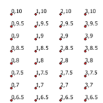
I’ve needed to create a measured grid of points for a variety of reasons in my GIS career. Here’s a flexible bit of code to create a grid of points spanning a vertical and horizontal range, at a specific interval for each – defined in the script. This method also allows any coordinate system and […]
Export MXDs in all subdirectories
This is an answer to the question in my post on batch exporting mxd’s in a folder. James asked about exporting all mxds in all subdirectories of a root folder. Thanks James for distracting me from my work this afternoon to solve this :). Below is the code to accomplish this. The first loop populates […]
Zip all shapefiles in directory individually
This script zips individual shapefiles within a defined directory. The zipfiles are named identical to the shapefile itself. This is useful for platforms like CartoDB and MapBox, especially if you are in an Esri workflow. If you are usging a geodatabase, it can be converted to shapefiles, then those shapefiles can be passed through this […]
Batch export mxds in a folder
Below is python to export all mxd’s in a given directory. I use this very often in my current workflow. This is used when data driven pages is either not appropriate or does not adhere to workflow standards. We need individual mxd’s for each map and each version of each map, individual maps can’t be […]


