Mitigating a broken Normal.mxt
For whatever reason, I’m constantly corrupting my Normal.mxt which causes ArcMap to crash before launching. The remedy is to delete the Normal.mxt at: C:\Users\*USER*\AppData\Roaming\ESRI\Desktop10.3\ArcMap\Templates\Normal.mxt which takes with it all my customization settings, the way my toolbars are set up in the interface and all the custom keyboard settings I have. The last time this happened, […]
My ArcMap keyboard shortcuts
These are the keyboard shortcuts I use to make ArcMap a little more illustrator-like. I think learning keyboard shortcuts is crucial to becoming more efficient and once you get in the habit and practice/force yourself to use them, it will pay dividends in productivity. To set them up, in ArcMap, go to Customize>Customize Mode and […]
Export map layers to gdb with python
Here’s a quick one. I have used this script many times as part of a data inventory workflow. It’s also been handy to start project databases with data from a variety of sources – so I can pluck data out of my source GIS databases into specific project databases. When used in conjunction with some […]
Point with label & auxiliary label in ArcMap

This is a walk-through on how to create an auto label like below in ArcMap. I’m using maplex on ArcGIS 10.3. A layer package corresponding to this can be downloaded here. I’m working with some fake levee breach data here with the goal to fit the breach number label onto a specific part of the custom […]
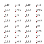
Grid of measured points with python

I’ve needed to create a measured grid of points for a variety of reasons in my GIS career. Here’s a flexible bit of code to create a grid of points spanning a vertical and horizontal range, at a specific interval for each – defined in the script. This method also allows any coordinate system and […]
