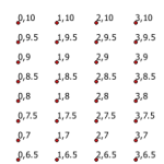
Grid of measured points with python

I’ve needed to create a measured grid of points for a variety of reasons in my GIS career. Here’s a flexible bit of code to create a grid of points spanning a vertical and horizontal range, at a specific interval for each – defined in the script. This method also allows any coordinate system and […]


